


Juliana Maantay
Introduction
.jpg) As a native of New York City, I have had a life-long interest in the urban environment, especially that of my home-town. I consider myself very fortunate to have a job that allows me to combine this fascination with urban culture, history, and the built environment with my passion for social justice issues. My previous education and professional background in architecture, urban planning, environmental management, and policy analysis, as well as my love for history, has been wonderful preparation to being a geographer, which is, in many ways, the ultimate inclusionary, cross-cutting, and multi-disciplinary field. The research areas I focus on are at the nexus of the sub-fields of urban, environmental, and health geography, and include using Geographic Information Science (GISc) for spatial analyses of environmental health justice issues; land use and health impacts; urban hazards and risk assessment; and community-based participatory research.
As a native of New York City, I have had a life-long interest in the urban environment, especially that of my home-town. I consider myself very fortunate to have a job that allows me to combine this fascination with urban culture, history, and the built environment with my passion for social justice issues. My previous education and professional background in architecture, urban planning, environmental management, and policy analysis, as well as my love for history, has been wonderful preparation to being a geographer, which is, in many ways, the ultimate inclusionary, cross-cutting, and multi-disciplinary field. The research areas I focus on are at the nexus of the sub-fields of urban, environmental, and health geography, and include using Geographic Information Science (GISc) for spatial analyses of environmental health justice issues; land use and health impacts; urban hazards and risk assessment; and community-based participatory research.
.jpg) Field work in the Galapagos Islands, studying marine iguanas on Fernadina Isle. (The Charles Darwin Research Station's research vessel, Beagle III)
Field work in the Galapagos Islands, studying marine iguanas on Fernadina Isle. (The Charles Darwin Research Station's research vessel, Beagle III)
.jpg) In the GISc Lab, working with NOAA-CREST students on the asthma and air pollution project (clockwise from seated left to right: Susan R. Miller, Holly Porter Morgan, Juliana Maantay, Juan Carlos Saborio, Dellis Stanberry)
In the GISc Lab, working with NOAA-CREST students on the asthma and air pollution project (clockwise from seated left to right: Susan R. Miller, Holly Porter Morgan, Juliana Maantay, Juan Carlos Saborio, Dellis Stanberry)
Education
- Cornell University, B.Sc., Design and Environmental Analysis, May 1973;
- New York University, M.U.P., Urban Planning, September, 1992;
- Hunter College, City University of New York, M.A., Geography/GISc, May 1995;
- Rutgers University, M. Phil., Urban Environmental Geography, May 1999;
- Rutgers University, Ph.D., Urban Environmental Geography, May 2000.
Professional Life
- Russo + Sonder Architects, 2/79-9/81, Design Director, Medical Facilities;
- Griswold, Heckel and Kelly Associates, 9/81-6/84, Senior Project Designer, Architecture and Planning;
- Sidney Gilbert and Associates, 6/84-3/86, Senior Project Manager, Architecture and Planning;
- Paine Webber, Inc., 3/86-11/90, Vice President, Architecture and Planning Division;
- Regional Plan Association, 4/91-9/92, Environmental Planning Associate, Environmental Programs;
- NYC Dept. of Environmental Protection, 9/92-10/95, Senior Environmental Planner, Environmental Assessment and Planning;
- The Center for a Sustainable Urban Environment, CUNY, 10/95-9/97, Associate Director, Community Environmental Analysis;
- NYC Dept. of City Planning, 9/97-8/98, Senior City Planner.
- Hunter College, 1995-1996, Adjunct Assist. Professor, Urban Affairs Graduate Program;
- Pratt Institute, School of Architecture, 1999-2000, Visiting Assistant Professor, City and Regional Planning Graduate Program;
- Lehman College/CUNY, 1998-2000, Instructor, tenure-track, Geology and Geography Dept.; 2000-2003, Assistant Professor, Geology and Geography Dept.; 2004-2009, Associate Professor, Environmental, Geographic, and Geological Sciences Dept.; 2010-Present, Professor, Environmental, Geographic, and Geological Sciences; 2009-2010, Chair, Environmental, Geographic, and Geological Sciences; 2001-Present, Director of Geographic Information Sciences (GISc) Program.
- CUNY Graduate Center, 2000-2003, Assistant Professor, Earth and Environmental Sciences, Geography Doctoral Program; 2004-2009, Associate Professor, Earth and Environmental Sciences, Geography Doctoral Program; 2010-Present, Professor, Earth and Environmental Sciences Ph.D. Program;
- CUNY Graduate Center, CUNY Graduate Center, 2008-2009, Associate Professor, Public Health Doctoral Program; 2010-Present, Professor, Public Health Doctoral Program;
Peer-Reviewed Journal Papers and Book Chapters
- Maantay, J.A., and Rajaee, Mozhgon, 2023. Mapping Environmental Health and Justice Issues, Chapter 9 in Sampson, N., Tallon, L. and DeJarnett, N. eds. Environmental Health: Foundations for Public Health. Springer: New York, NY. 66 pages.
- Jimenez, R. and Maantay, J.A., 2022. Expulsive Greening: A Cross-Sectional Analysis of Resilience-Era Green Gentrification in Brooklyn, New York. Cities and the Environment, 16(1): Article 3, 33 pages.
- Maantay, J.A., and Winner, A., 2021. Geospatial Analysis of the Urban Health Environment in Geospatial Technology for Human Well-Being and Health, Faruque, F., ed. Springer-Verlag: Dordrecht, NL. Chapter 9, 40 pages.
- Maantay, J.A., and Winner, A., 2021. Spatial Analysis of Urban Health, in Geospatial Technology for Human Well-Being and Health, Faruque, F., ed. Springer-Verlag: Dordrecht, NL. Chapter 9, 40 pages.
- Maantay, J.A., Maroko, A.R., Anguelovski, I., & Connolly, J., 2020. The Paradox of Urban Greening: Does it Harm the Very People Who Need it the Most? The Constructed Environment, 10(4): 25 pages.
- Anguelovski, I., Checker, M, Connolly, J.J.T., Gould, K., Lewis, T., Maantay, J.A., Maroko, A.R., Pearsall, H., Timmons Roberts, J., Shokry, G., 2019. Why green "climate gentrification" threatens poor and vulnerable populations. Proceedings of the National Academy of Sciences of the United States of America, 116(52).
- Maroko, A.R., Maantay, J.A., Machado, R. P. P., & Barrozo, L.V., 2019. Improving Population Mapping and Exposure Assessment: 3-Dimensional Dasymetric Disaggregation in New York City and São Paulo, Brazil. Papers in Applied Geography, 5(2): 45-57.
- Maantay, J.A., 2019. Environmental Justice and Fairness. Routledge Companion to Environmental Planning, Davoudi, S.; Cowell, R.; White, I.; and Blanco, H., eds. Routledge: Oxford, UK.
- Maantay, J.A. and Maroko, A.R., 2018. Brownfields to Greenfields: Environmental Justice versus Environmental Gentrification. International Journal of Environmental Research and Public Health, 15, 2233; 17 pages.
- Strode, G.; Maantay, J.A.; Mesev, V., 2018. Improving dasymetric population estimates for land parcels: Data pre-processing steps. Southeastern Geographer, University of North Carolina Press 58(3): 300-316.
- Maantay, J.A., and Maroko, A.R., 2017. Assessing population at risk: Areal interpolation and dasymetric mapping, in: Walker, G., Holifield, R., eds., Handbook of Environmental Justice, Routledge, UK.
- Maantay, J.A., and Maroko, A.R., 2015. ‘At-risk’ places: inequities in the distribution of environmental stressors and prescription rates of mental health medications in Glasgow, Scotland. Environmental Research Letters, 10 (16 pages).
- Maantay, J.A., 2013. The Collapse of Place: Derelict Land, Deprivation, and Health Inequality in Glasgow, Scotland. Cities and the Environment, 6(1): Article 10 (55 pages).
- Viola, D., Arno, P., Maroko, A., Schechter, C., Sohler, N., Maantay, J.A., 2013. Overweight and obesity: Can we reconcile evidence about supermarkets and fast food retailers for Public Health Policy? Journal of Public Health Policy, (15 pages).
- Maantay, J.A., Becker, S., 2012. The Health Impacts of Global Climate Change: A Geographic Perspective, Journal of Applied Geography, 33: 1-4.
- Maantay, J.A., Becker, S., eds., 2012. The Health Impacts of Global Climate Change: A Geographic Perspective, Special Issue of the Journal of Applied Geography, 33: 1-106.
- Ottmann, M., Maantay, J.A., Grady, K., and Fonte, N., 2012. Characterization of Urban Agricultural Practices and Gardeners' Perceptions in Bronx Community Gardens, New York City. Cities and the Environment, 5(1): Article 13 (27 pages).
- Maantay, J.A., 2012. Derelict Land, Deprivation, and Health Inequality in Glasgow, Scotland: The Collapse of Place, Mackintosh School of Architecture, Glasgow Urban Lab Working paper (36 pages). Published on-line at http://www.gsa.ac.uk/research/research-centres/glasgow-urban-lab/
- Chakraborty, J., Maantay, J.A., and Brender, J., 2011. Disproportionate Proximity to Environmental Hazards: Methods, Models, and Measurement. American Journal of Public Health, 101 (S1): S27-S36.
- Brender, J. and Maantay, J.A., and Chakraborty, J., 2011. Residential Proximity to Environmental Hazards and Adverse Health Outcomes. American Journal of Public Health, 101 (S1): S37-S52.
- Chakraborty, J., and Maantay, J.A., 2011. Proximity Analysis for Exposure Assessment in Environmental Health Justice Research, in Maantay, J.A., and McLafferty, S., eds., Geospatial Analysis for Environmental Health, volume in series “Geotechnologies and the Environment” Springer-Verlag, pp. 111-138.
- Maantay, J.A., McLafferty, S., 2011. Environmental Health and Geospatial Analysis: An Overview, in Maantay, J.A., and McLafferty, S., eds., Geospatial Analysis for Environmental Health, volume in series “Geotechnologies and the Environment” Springer-Verlag, pp. 3-37.
- Maroko, A.R., Maantay, J.A., and Grady, K., 2011. Using Geovisualization and Geostatistics to Explore Respiratory Disease and Environmental Health Justice in New
- York City, in Maantay, J.A., and McLafferty, S., eds., Geospatial Analysis for Environmental Health, volume in series “Geotechnologies and the Environment” Springer-Verlag, pp. 39-66.
- Weiss, R.C., Fahs, M.C., and Maantay, J.A., 2010. Promoting Active Urban Aging: Creating a Combined Walkability Index for Older Adults Using a Geographic Information System. Gerontologist, 50 (10): 35.
- Miyake, K., Maroko, A.R., Maantay, J.A., Grady, K., Arno, P., 2010. Not Just A Walk in the Park: methodological improvements for determining environmental justice implications of park access in NYC. Cities and the Environment, 3(1): article 8 (17 pages).
- Weiss, R., Maantay, J.A., Fahs, M., 2010. Promoting Active Urban Aging: A Measurement Approach to Neighborhood Walkability for Older Adults. Cities and the Environment, 3(1): article 12 (17 pages).
- Maantay, J.A., Ottmann, M., Grady, K., 2010. Urban Agriculture, Green Infrastructure, and Urban Ecology: A Case Study of the South Bronx, NYC. Cities and the Environment, 3(1): article 20.
- Maantay, J. A., Maroko, A.R., 2009. Asthma and air pollution in the Bronx: Using the Cadastral-based Expert Dasymetric System (CEDS) to improve population mapping and understanding the spatiality of disease in urban areas. Journal of Urban Health (Bulletin of the New York Academy of Medicine), 86(3): 353-354.
- Maantay, J.A., Tu, J., Maroko, A., 2009. Loose-coupling an Air Dispersion Model and a Geographic Information System (GIS) for Studying Air Pollution and Asthma in the Bronx, New York City. International Journal of Environmental Health Research, 19(1):59-79.
- Maroko, A.R., Maantay, J.A., Sohler, N.L., Grady, K., Arno, P., 2009. The complexities of measuring access to parks and physical activity sites in New York City: a quantitative and qualitative approach. International Journal of Health Geographics, 8(34):1-23.
- Bernstein, S.L., Cabral, L., Maantay, J.A., Peprah, D., Lounsbury, D., Maroko, A.R., Murphy, M., Shelley, D., 2009. Disparities in Access to Nicotine Replacement Products in New York City Pharmacies. American Journal of Public Health, 99 (9):1699-1704.
- Maantay, J.A., Maroko, A.R., and Culp, G., 2009. Using Geographic Information Science to Estimate Vulnerable Urban Populations for Flood Hazard and Risk Assessment in New York City, in Showalter, P., and Lu, Y. eds., Geotechnical Contributions to Urban Hazard and Disaster Analysis, Chapter 5, pp. 71-97, Springer-Verlag.
- Maantay, J. A., and Strelnick, A. H., 2009. Geographic Information Systems, Environmental Justice, and Health Disparities: The Need for An Interdisciplinary Approach to Study Asthma and Air Pollution in the Bronx, New York, in Freudenberg, N., Saegert, S., and Klitzman, S., eds., Urban Health and Society: Interdisciplinary Approaches to Research and Practice, Chapter 5, pp. 93-126. Jossey Bass.
- Maantay, J.A., Maroko, A.R., 2008. Mapping urban risk: Flood hazards, race, & environmental justice in New York. Applied Geography, 29 (1):111-124.
- Maantay, J.A., Maroko, A.R., Porter-Morgan, H., 2008. A New Method for Population Mapping and Understanding the Spatial Dynamics of Disease in Urban Areas. Urban Geography, 29(7):724-738.
- Maantay, J.A., Maroko, A.R., and Herrmann, C., 2007. Mapping Population Distribution in the Urban Environment: The Cadastral-based Expert Dasymetric System (CEDS). Cartography and Geographic Information Science, 34 (2):77-102. Special issue: Cartography 2007: Reflections, Status, and Prediction.
- Maantay, J.A., 2007. Asthma and Air Pollution in the Bronx: Methodological and Data Considerations in Using GIS for Environmental Justice and Health Research. Health and Place, 13:32-56. Special issue: Linking Population Health, Critical Theory, and Geographical Information Science.
- Clarke, M., and Maantay, J.A., 2006. Optimizing Recycling in all of New York City’s Neighborhoods: Using GIS to Develop the REAP Index for Improved Recycling Education, Awareness, and Participation. Resources, Conservation, and Recycling, 46(2):128-148.
- Maantay, J.A., 2004. The Geography of Environmental Injustice, in Janelle, D., Warf, B., and Hansen, K., eds. WorldMinds: Geographical Perspectives on 100 Problems. Commemorating the 100th Anniversary of the Association of American Geographers, 1904 – 2004. Kluwer Academic Press: Dordrecht, NL. pp. 163-169.
- Maantay, J.A., 2003. Zoning, Equity, and Public Health, in R. Hofrichter, ed., Health and Social Justice: A Reader on Politics, Ideology and Inequity in the Distribution of Disease, JosseyBass/John Wiley & Sons, pp. 228–250.
- Maantay, J.A., and Strelnick, H., 2003. Mapping Asthma Hot Spots: The Geography of Asthma and Air Pollution in the Bronx. Journal of Urban Health, Bulletin of the New York Academy of Medicine, 80 (Supp. 2):11.
- Maantay, J.A., 2002. Industrial Zoning Changes in New York City and Environmental Justice: A Case Study in “Expulsive” Zoning. Projections: the Planning Journal of Massachusetts Institute of Technology (MIT), pp. 63-108. Special issue: Planning for Environmental Justice.
- Maantay, J.A, 2002. Zoning Law, Health, and Environmental Justice: What’s the Connection? Journal of Law, Medicine, and Ethics, pp. 572-593. Special issue: Health, Law, and Human Rights.
- Maantay, J.A., 2002. Mapping Environmental Injustices: Pitfalls and Potential of Geographic Information Systems (GIS) in Assessing Environmental Health and Equity. Environmental Health Perspectives, 110, Supp. 2:161-171. Special issue: Advancing Environmental Justice Through Community-Based Participatory Planning.
- Maantay, J.A., 2001. Zoning, Equity, and Public Health. American Journal of Public Health, 91(7):1033–1041.
.jpg)
Fulbright Distinguished Chair Award, 2011-2012, Mackintosh School of Architecture, Glasgow Urban Lab
- American Planning Association's Robert C. Weinberg Award for Academic Excellence in Urban Planning, 1992;
- Center for Spatially Integrated Social Science, Scholarship at UC Santa Barbara, Summer 2001, Resident program in Point Pattern Analysis and Geostatistics for Science Faculty;
- George N. Shuster Fellowship, 2002, “Modeling Asthma and Air Pollution in the Bronx;”
- Hispanic Educational Telecommunications System (HETS) Fellowship, 2002. “Basic Epidemiology with a Focus on Hispanics;”
- George N. Shuster Fellowship, 2004, “Mining the Urban Environment: Improving Recycling Participation in New York City;”
- George N. Shuster Fellowship, 2006, “Health Disparities and Residential Segregation in New York City: Mapping TB and AIDS in Conjunction with Segregation Indices;”
- American Congress on Surveying and Mapping – Cartography and Geographic Information Society 34th Annual Map Competition Awards for 2006 – Atlas/Book, Professional Category, for the book “GIS for the Urban Environment;”
- Planetizen’s Top Planning Books for 2007 – GIS for the Urban Environment;
- International Union of Population Scientists Conference,Marrakech, Morocco, 2009. “The Cadastral-based Expert Dasymetric System (CEDS) for Mapping Population Distribution and Vulnerability in New York City,” – Honorable Mention in a field of 600+ posters.
- Fellow of the Royal Geograohical Society, 2011
- Fulbright Distinguished Chair Award, 2011-2012, Mackintosh School of Architecture, Glasgow Urban Lab “Health, Justice, and the Built Environment: A Case Study Comparison of New York City and Glasgow.”
Dissertation Advisor to Doctoral Students
- Philippe Amstislavski (CUNY Graduate Center– Geography – Earth and Environmental Sciences/Lehman, Ph.D. 2012) Access to Urban Food Outlets as a Predicator of Diabetes
- Jennifer Brisbane, (CUNY Graduate Center– Geography – Earth and Environmental Sciences/Lehman, Ph.D. 2014) The Historical Relationships Between Land Elevation and Socioeconomic Status in New York City: A Mixed Methods GIS Approach
- Gretchen Culp (CUNY Graduate Center– Geography – Earth and Environmental Sciences/Lehman) Increasing Accessibility for Map Readers with Acquired and Inherited Color Vision Deficiencies: A Re-Coloring Algorithm for Maps
- Michael Dorsch (CUNY Graduate Center– Geography – Earth and Environmental Sciences/Lehman)
- Marzie Jafari CUNY Graduate Center– Geography – Earth and Environmental Sciences/Lehman, Ph.D. 2008) Using a geographic information system to develop a marketing geographic segmentation model for Continuing Education programs
- Rose Jimenez (CUNY Graduate Center – Geography – Earth and Environmental Sciences/Lehman) Mapping the Green Infrastructure Landscape and Green Gentrification in Brooklyn and Queens, New York
- Andrew R. Maroko (CUNY Graduate Center– Geography – Earth and Environmental Sciences/Lehman, Ph.D., 2010) Chronic Exposure to Fine Particulate Matter and Heart Failure in New York City: A Methodological Exploration of Environmental Justice and Health
- Lesley Patrick (CUNY Graduate Center– Geography – Earth and Environmental Sciences/Lehman, Ph.D. 2014) The Impacts of Sea Level Rise on New York City: Mapping Exposure, Vulnerability, and Coastline Change
- Shaky Sherpa (CUNY Graduate Center– Geography – Earth and Environmental Sciences/Lehman)
- Angelika Winner (CUNY Graduate Center– Geography – Earth and Environmental Sciences/Lehman)
- Paradorn Wongchanapai (CUNY Graduate Center – Geography – Earth and Enviornmental Sciences/Lehman) Under-Five Mortality (U5MR) By Districts of India: The Spatial and Environmental Analysis
Dissertation Committee Member for
- Moira Conway (CUNY Graduate Center– Geography – Earth and Environmental Sciences/Brooklyn, Ph.D. 2014) Gravity Modeling of Casinos in the United States: A Case Study of Philadelphia
- Heather Glickman (CUNY Graduate Center– Geography – Earth and Environmental Sciences/CCNY) Urban Heat Island Effect
- Lee Hadchadorian (CUNY Graduate Center– Geography – Earth and Environmental Sciences/Hunter, Ph.D. 2011) Tiebout Sorting and Jurisdictional Homogeneity: Empirical Validity and Ethical Implications
- Christopher Herrmann (CUNY Graduate Center - John Jay – Criminal Justice, Ph.D. 2010)
- Katie Himmelfarb (Rutgers University, Urban Planning, Ph.D. 2014) Policy Purpose from Formation to Implementation in New York State's Brownfields Cleanup Program
- Cesar Marin (CUNY Graduate Center – Biology/Ecology Program, Lehman) Modeling Forest Fire Risk in Columbia's National Parks
- Jessica Miller (CUNY Graduate Center– Geography – Earth and Environmental Sciences/Brooklyn) Contamination, Green Gentrification, and Displacement: A Case Study of the Gowanus Canal in Brooklyn, NY
- Katera Moore (CUNY Graduate Center– Geography – Earth and Environmental Sciences/Brooklyn, Ph.D. 2014) In Harm's Way: How Philadelphia's Urban Renewal Practices Steered Marginal People to Marginal
- George Musa (CUNY Graduate Center– Geography – Earth and Environmental Sciences/Hunter, Ph.D. 2012) Does Geography Matter? Neighborhood Effects on Post-Traumatic Stress Disorder of NYC Public School Children after 9/11
- Sheetal Ranjan (CUNY Graduate Center - John Jay – Criminal Justice, Ph.D. 2009) Intimate Partner Violence: An Examination of Ecological Factors
- Holly Porter-Morgan (CUNY Graduate Center – Biology/Plant Sciences Program/Lehman, Ph.D. 2007) Thrips as Primary Pollinators of Sympatric Species of Chamaedorea (Arecaceae) in Belize
- Robert Svadlenka (CUNY Graduate Center– Geography – Earth and Environmental Sciences/Hunter) An Investigation of the Determinants of Land Use Change in the East Kordofan District of Central Sudan from 1982 to 2007
- Rachael Weiss, (CUNY Graduate Center – Public Health DPH/Lehman) Incorporating Place and Space: A Hierarchical Spatial Approach to Exploring Potentially Preventable Coronary Heart Failure Hospitalizations in New York City
- The American Conservative, November, 2018. “When Did Gentrificaiton Become a Dirty Word?” By Dan McGraw, (New Urbanism section).
- Planetizen, June 27, 2016 “Glasgow's High Mortality Rate and a History of Poor Planning”
- The Guardian, June 10, 2016 “The Glasgow Effect: ‘We Die Young Here - But You Just Get on With It’”
- Environmental Research Web: Science, Policy, Engagement, February 22, 2016 “Mental disorders linked to derelict land”
- Making of Cities Journal, February 8, 2016 "Towards environmental justice: The 'Stalled Spaces' Effect"
- Philly News, August 13, 2014 “Chester's new trash complex stirs debate”
- Mayor Di Blasio and City Council Environmental Protection Committee,May 14, 2014 “PlaNYC Initiative 17 – Development of a Smarter & Cleaner Electric Utility Grid”
- Ecology, Evolution, and Conservation: The Drew Lab at Columbia University, April 11, 2014 "Conservation Science and Justice in the City"
- Daily Mail (UK), November 25, 2012 “Could these barriers protect New York from going underwater? Barrier designs may shield from rising waters - as new data shows flooding could cover Manhattan within 300 years”
- Huffington Post, November 25, 2012 "New York Harbor Barrier: Will City Act To Protect Itself From Future Storm Surges?"
- Staten Island Live, November 25, 2012 "Staten Islanders wonder: Will New York City act to block future surges?"
- The Herald (Glasgow, UK), April 24, 2012 "Living near wasteland 'is bad for your health'"
- New York State Senate Publications (State Senator Jeffrey D. Klein), July, 2011 "Asthma Prevention and Management in Bronx, New York and New York State at Large"
- City Farmer News, November 18, 2011 “Community Gardens: An Exploration of Urban Agriculture in the Bronx, New York City”
- The Manhattan Times, May 4, 2011 “Community Gardens Provide Oases in Bronx ‘Food Deserts’”
- New York State Reports, December, 2009 "Environmental Justice Issue Brief New York State Energy Plan"
- The Bronx Journal, March 21, 2007 "The Bronx: In Search of a Breath of Fresh Air"
- Daily News, February 3, 2003 “Students Connecting the Dots on Asthma”
- Caribbean News, January 22, 2003 “Lehman Students Win First Place Award”
- CUNY TV’s “Study with the Best” Television program - Lehman GISc Students and Prof. Maantay appeared in a segment of “Study with the Best,” on CUNY TV focusing on the asthma project. This show was broadcast several times in October and November 2003.
- Bronx Beat, May 4, 2003, “Showcasing the Borough’s Underbelly”
- Baltimore City Paper, May 14, 2003, “Halfway There: Hollins Market Residents Say Influx of Drug-treatment Centers and Group Houses is Hurting the Neighborhood”
- Gotham Gazette: New York City News and Policy, May, 2004 “Residential Segregation”
- NY 1 News/Time Warner Cable TV - Interview “Researchers Find Proof Of Causal Link Between Asthma, Pollution In The Bronx,” broadcast on February 7, 2007. NY1 “Health Beat”
- New York Daily News, February 13, 2007 “Most Nabes are Toxic: Researcher Warns of Boro ‘Health Crisis’”
- Riverdale Press, February 15, 2007 - “Researcher Links Asthma, Pollution”
- Bronx Beat, May 7, 2007 “Pollution Hot Spots Mapped in Survey”
- Daily News, March 27, 2007 “Health Risk Zones Tied to Traffic”
- CUNY Matters, Spring 2007 “Lehman Finds Asthma and Dirty Air Links in NYC”
- Talk Bronx, May 18, 2008 “Ladies and Gentlemen: The Bronx is Choking!”
- Inside Lehman, December 5, 2008 segment interviewing me and students working on the asthma and air pollution research
- New York Daily News, January 6, 2009 "City to monitor air quality for 1st time"
.jpg)
Students in GEP 690/EES 79904 Workshop in GISc Research, Spring term 2011.
Back row, standing, left to right:
Kristen Grady (EES Doctoral Program); Hildegaard Link (EES Doctoral Program); Prof. Maantay; Aviva Rahmani (GISc Graduate Program); Emily Peterson-Perez (GISc Graduate Program); Zakkiyyah Shah (Geography/GISc Program); Tiffany Mae Brown (GISc Graduate Program, GISc Lab Tutor); Cordelia Nervi (GISc Graduate Program).
Front Row, Seated, left to right:
Ronald Alphonse (GISc Graduate Program); Brian Morgan (Geography/GISc Program, GISc Lab Manager); Rachel Goffe(EES Doctoral Program); Patricia Reed (GISc Graduate Program)
I teach both GEP 350/650, Special Projects in GISc: Environmental Modeling and Spatial Analysis in the Fall terms; and GEH 490/GEP 690,Workshop in GISc Research in the Spring terms. Many students take these two courses as a sequence, and they are both required for the Certificate Program in GISc, as well as for the MS-GISc (PEAR Option). I will also be teaching GEP 310/610/PHE 717, Geographies of Urban Health/Spatial Analysis of Urban Health, in Spring 2014. GEP 470/670, GISc Internship Seminar, is offered every Fall and Spring terms under my supervision.
GEP 350/605, Special Projects in GISc: Environmental Modeling and Spatial Analysis is an intermediate-level GISc course, focusing on real-world environmental applications of GISc. In this course, we build on the principles of GISc presented in the introductory courses, but delve deeper into GISc concepts and geographic theory, develop basic environmental models, conduct complex spatial analyses, engage in quantitative reasoning as well as qualitative methods, and create advanced cartographic products. But most importantly, students in this class use what they have learned in order to design a GISc research project based on their individual interests.
In past years, these student projects have included such diverse topics as adapting a model to estimate sea ice thickness in Antarctica; conducting an historical analysis of the relationship between elevation and socio-economic class in NYC; calculating the earthquake hazard in the Bronx; developing a hazard vulnerability assessment tool for flooding in NYC; examining the historical process of gentrification/neighborhood change in north Philadelphia; mapping the distribution of sandalwood trees in Fiji; modeling forest fire risk in Colombia; assessing the impacts of tourism on deforestation in Nepal; estimating fish species richness in the Bronx River; studying the process of gentrification in Greenpoint-Willismsburg, Brooklyn; and predicting the optimal locations for carbon sequestration sites in the U.S., to name only a few.
GEH 490/GEP 690, Workshop in GISc Research is a very interesting and challenging class where students have the opportunity to implement their project ideas that they developed during the prior term in GEP 350/605. Because the students have developed project concepts that reflect their own interests, there is always a very wide diversity of project topics, utilizing various methodologies and data sets, and representing all different parts of the world for their geographic study extents. Students benefit from all the cross-pollination of ideas and subject matter, and generally learn a considerable amount, not only about GISc and its applications, but also background information on many other topics that are being explored by the other students in the class, and which are often applicable to their own work. Projects are meant to be substantive and comprehensive, including thoroughly researched background information, a critical analysis of the relevant body of literature, a well-designed hypothesis and methodology, GISc analysis and interpretation of the results. Students are expected to make a professional-quality presentation, prepare a final report, and create a poster summarizing their work.
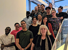 GEP 690 Workshop in GISc Research class of 2018. Students normally take this capstone research course in their final term in the MS-GISc Program or GISc Certificate Program. Most of the students shown here graduated shortly after this photo was taken.
GEP 310 Geographies of Urban Health/GEP 610 Spatial Analysis of Urban Health focuses on urban health issues using a geographical framework and covers topics such as the historical perspective of health, place, and society; mapping and measuring health and health impacts; the social and spatial patterning of health; the geography of health inequalities and disparities; health and social/spatial mobility; and the effects of urban segregation, overcrowding, and poverty on disease. Current research, as well as the seminal early works on the geographies of health, will be reviewed. Geographic Information Science will be used in the laboratory exercises to illustrate the theoretical concepts and to produce worked examples of health geography.
.jpg)
Fall 2014 students who completed GISc Internships (GEP 470/GEP 670, GISc Internship Seminar). From left:Tonya Lavender-Davis (Voice Unbroken, Bronx not-for-profit organization); Michael Sullivan (NYC Dept. of Information Technology and Telecommunication – DoITT); Carimaxy Benitez (Neighbors Allied for Good Growth – NAGG – Brooklyn not-for-profit organization); Keri-Dean Scarlett (US Environmental Protection Agency - EPA); Ragnar Thrastarson, Amelia Zaino, Meg Baker, Mary Grey, (all at NYC Dept. of City Planning); Cristina Sarkissian(DoITT); Li Chen (NYC Dept. of City Planning)
GEP 470/GEP 670 GISc Internship Seminar involves discussions on current issues in the Geographic Information Science (GISc) profession, with weekly work as an intern in one of various governmental, non-profit, academic, or consulting organizations. The course requires a minimum 150 hours of GISc-related project work.
.jpg)
GEH 267/GEH 630/GEP 380/GEP 680 Exploring the Geography of NYC with GISc. An exploration through maps and other archival documents, as well as readings and videos, how NYC came to be what it is today – its landscape, demographic diversity, cultural prominence, changing economy, and creation of life-sustaining “systems,” such as our water infrastructure, transportation network, public health system, parks and natural environment, and local government. Using the NYC Open Data Portal and other geospatial databases, students will analyze data on natural, socio-demographic, economic, built environment, and cultural phenomena, focusing on case study neighborhoods, and create geovisualizations and cartographic representations based on their analyses.
Dr. Juliana Astrud Maantay, Professor and Director of the Geographic Information Science Program, and the Urban GISc Lab
Department of Earth, Environmental, and Geospatial Sciences (EEGS)
Gillet Hall, Room 325
Lehman College, City University of New York (CUNY)
250 Bedford Park Blvd. West
Bronx, NY, 10468
Tel: (718) 960-8574; FAX:(718) 960-8584;
e-mail: Juliana.Maantay@lehman.cuny.edu