


Introduction
My research interests are applied geologic science in the area of investigating long-term scale hazards (e.g. sea-level rise, deglaciations, climate change, etc.) and short-term scale disasters (earthquakes, hurricanes, floods, etc.); understanding and identifying vulnerability and risk components, finding and quantifying physical and other related conditions of hazards and disasters; expanding applications of new data and methods in studying and modeling contemporary and historical environments turning natural hazards into disasters.
FROM LOCAL BUCKETS TO GLOBAL SKY
Education
- Odessa State University (Ukraine) Engineering/Marine Geology M.S., 1983
- City University of New York Earth and Environmental Sciences Ph.D., 1999 Graduate Center
Appointments
- 2014 – present Associate Professor, Department of Earth, Environmental, and Geospatial Sciences, Lehman College, City University of New York
- 2007 – 2014 Assistant Professor, Department of Earth, Environmental, and Geospatial Sciences, Lehman College, City University of New York
- 1999 – present Adjunct Assistant Professor, Department of Earth and Environmental Engineering, Columbia University.
- 2003 – 2007 Associate Research Scientist, Center for International Earth Science Information Network (CIESIN), Columbia University
- 2000 – 2003 Assistant Professor, Department of Environmental Sciences, State University of New York, Purchase College
- 1992 – 2000 Research Scientist, GIS Manager, New York City Department of Environmental Protection
- 1983 – 1989 Research Scientist, Marine Geology and Geomorphology, Odessa State University, Ukraine
- Machado E., Y. Gorokhovich, M. Ghahremani. 2022. Landslide inventory dataset post Hurricane Stan (2005), Lake Atitlan region, Guatemala. Data in Brief (43), August, 2022. https://doi.org/10.1016/j.dib.2022.108356
- Tian Y., N.J. Themelis, A.C.(Thanos) Bourtsalas, S. Kawashima, Y. Gorokhovich. 2022. Systematic study of the formation and chemical/mineral composition of waste-to-energy (WTE) fly ash. Materials Chemistry and Physics. Available online 5 October 2022, 126849. https://www.sciencedirect.com/science/article/pii/S0254058422011555?via%3Dihub . DOI: 10.1016/j.matchemphys.2022.126849
- Velez R., D. Calderon, L. Carey, C. Aime, C. Hultquist, G. Yetman, A. Kruczkiewicz, Y. Gorokhovich, and R. S. Chen. 2022. Advancing Data for Street-level Flood Vulnerability: Evaluation of Variables Extracted from Google Street View in Quito, Ecuador. IEEE Open Journal of the Computer Society, 3, 51-61, doi: 10.1109/OJCS.2022.3166887.
- Gorokhovich Y., K. K. Cawse-Nicholson, N. Papadopoulos, D. Oikonomou. 2022. Use of ECOSTRESS data for measurements of the surface water temperature: significance of data filtering in accuracy assessment. Remote Sensing Applications: Society and Environment, 26, 2022, 100739. https://doi.org/10.1016/j.rsase.2022.100739
- Hall, J., M. Scholl, Y. Gorokhovich, M. Uriarte. 2022. Forest cover lessens the impacts of drought on stream runoff in Puerto Rico. Hydrological Processes, 36 (5). https://doi.org/10.1002/hyp.14551
- Gorokhovich Y., and A.Voustianiouk. 2021. Implications of slope aspect for landslide risk assessment: a case study of Hurricane Maria in Puerto Rico in 2017. Geomorphology, 391, 107874.https://doi.org/10.1016/j.geomorph.2021.107874
- Livingston, R., C. Grissom and Y. Gorokhovich. 2020. Portable XRF Study of the geographic distribution and growth rate of mn-rich rock varnish. Monument Future Decay and Conservation - Proceedings of the 14th International Congress on the Deterioration and Conservation of Stone. S. Siegesmund and B. Middendorf. Halle, Germany, Mitteldeuscher Verlag: 161-166.
- Ozcelik C., and Y. Gorokhovich. 2020. An Overland Flood Model for Geographical Information Systems. Water, 12, 9, 1 - 20
- Gorokhovich Y. K. Block, C. McNeil, E. Barrios, M. Marionkova. 2020. Mercury source in Copan (Honduras): local mining or trade? Journal of Archaeological Science: Reports, 33, 1 - 11
- Gorokhovich, Y.A., M.Nelson, T. Eaton, J.Wolk-Stanley, G. Sen. 2018. Geochronology and geomorphology of the Jones Point glacial landform in Lower Hudson Valley (New York): Insight into deglaciation processes since the Last Glacial Maximum. Geomorphology, 321, 87-102
- Gorokhovich, Y., E.A. Machado, L.I.Giron Melgar, M. Gahremani.2016.Improving landslide hazard and risk mapping in Guatemala using terrain aspect. Natural Hazards, 81(2), 869-886
- Gorokhovich, Y. Turbidity. 2016. In: M.J. Kennish (ed.), Encyclopedia of Estuaries, Springer-Verlag, 720-721
- Gorokhovich, Y., Papadopoulos, N., Soupios, P., Barsukov, P. 2014. Application of Geographic Information Systems, Ground Penetrating Radar and Transient Electromagnetic Methods for Locating Water Supply Structures at the ancient site of Aptera in Crete. Boletin Geologico y Minero, 125 (3): 273-284
- Doocy S., E. Russel, Y. Gorokhovich, T. Kirsch. 2013. Disaster Preparedness and Humanitarian Response in Flood and Landslide-Affected Communities in Eastern Uganda. Disaster Prevention and Management, 22 (4), pp.326 - 339
- S. Agrawal, Y Gorokhovich, S Doocy.2013. Risk factors for injuries in landslide- and flood-affected populations in Uganda. Prehosp Disast Med.28(4):1-9
- Gorokhovich Y., A. Leiserowitz, D. Dugan. 2013. Impact of sea-level rise and coastal erosion on subsistence resources in Northwest Alaska. Journal of Coastal Research In-Press.doi: http://dx.doi.org/10.2112/JCOASTRES-D-13-00001.1
- Gorokhovich Y. 2013. Santorini Eruption. In: Ed. P. Bobrowsky, “Encyclopedia of Natural Hazards”, Springer-Verlag, pp. 884-895.
- Rinterknecht V., A. Matoshko, Y.Gorokhovich, D. Fabel. 2012. Expression of the Younger Dryas cold event in the Carpathian Mountains, Ukraine. Quaternary Science Review, 39: 106-114
- Ozcelik C., Y.Gorokhovich, S. Doocy. 2012.Storm Surge Modeling with Geographic Information Systems: Estimating Areas and Population Affected by Cyclone Nargis. International Journal of Climatology, 32: 95–107
- Gorokhovich Y., A. Leiserowiz. 2012. Historical and Future Coastal Changes in Northwest Alaska. Journal of Coastal Research, 28 (1A), pp. 174-186
- Gorokhovich Y., L. Mays, L. Ullmann. 2011. A survey of ancient Minoan water technologies. Water Science and Technology, 11 (4), 388 -39
- Gorokhovich Y., S. Doocy, A. Voustianiouk, C. Small. 2010. Assessment of mortar and brick strength in earthquake-affected structures in Peru using a Schmidt Hammer. Journal of Performance of Constructed Facilities. American Society of Civil Engineering. Posted ahead of print 16 January 2010. Permalink: http://dx.doi.org/10.1061/(ASCE)CF.1943-5509.0000120
- Milch K, Y. Gorokhovich, S. Doocy.2010.The Inppares-JHSPH-CUNY Study Team, and S. Doocy. Effects of Seismic Intensity and Socioeconomic Status on Displacement after the 2007 Peru Earthquake. Disasters. no. doi: 10.1111/j.1467-7717.2010.01188.x
- Mays L., Y. Gorokhovich. 2010. Water technology in the ancient American societies. In: Ed. L. Mays, “Ancient Water Technologies”, Springer Verlag, pp. 171 – 200.
- Gorokhovich Y., L. Ullman. 2010. Ground water resources and earthquake hazards: ancient and modern perspectives. In: Ed. L. Mays, “Ancient Water Technologies”, Springer Verlag, pp. 201 – 216.
- Gorokhovich Y., V. Rinterknecht, J. Rogers. 2009. Post-Younger Dryas deglaciation of the Greenland western margin as revealed by spatial analysis of lakes. Journal of Earth Surface Processes and Landforms, 34, pp. 801- 809.
- Rinterknecht V.R., Y. Gorokhovich, J. Schaefer, M. Caffee. 2009. Preliminary 10Be Chronology for the Last Deglaciation of the Western Margin of the Greenland Ice Sheet. Journal of Quaternary Science, 24 (3) pp. 270-278
- Gorokhovich Y., G. Fleeger. 2007. Pymatuning Earthquake in Pennsylvania and Late Minoan Crisis on Crete. Water Science & Technology: Water Supply, Vol 7, No 1, pp 245–251
- Gorokhovich Y. 2005. Abandonment of Minoan Palaces on Crete in Relation to the Earthquake Induced Changes in Ground Water Supply. Journal of Archeological Sciences, 32 (2), pp. 217-222
Recent Research Projects
2010. Assessment of floods and landslides in Uganda.
The project was conducted as a part of NSF grant together with the team from John Hopkins University, School of Public Health. Severe rains during March – April caused enormous flooding in Butaleja County and deadly landslide in village of Nametsi, province of Bududa. One of the undergraduate students from Lehman College, Mr. Tahjib Saman participated in surveys.
- The blog regarding the project is available here.
Video clips: (two parts)
Publications
- Preliminary report is available on ReliefWeb
Photos
.jpg)
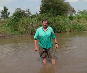
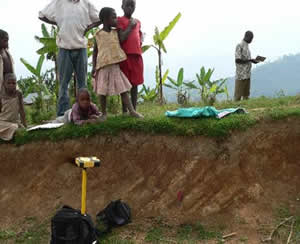
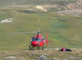
During measurements of the discharge on Manafwa River, Butaleja County, Uganda
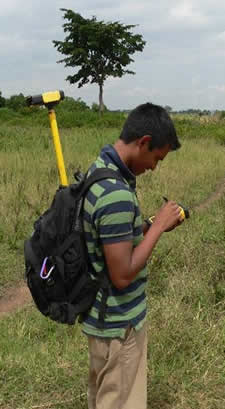
Mr. Tahjib Zaman, student, Lehman College during floodplain survey with GPS.
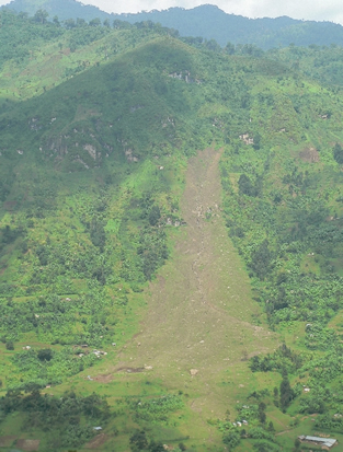
Deadly landslide in Nametsi villeage, Bududa province. This landslide buried almost 300 people.
Geologic mapping of slopes in the landslide area near Nametsi, Uganda
2008 - 2009. Community based GIS mapping of subsistence resource in Northwestern Borough of Alaska. This project was conducted as part of NOAA grant “Assessment of the Vulnerability of the Northwestern Arctic Borough Coast to the Sea-Level Rise Induced by Climate Change” together with the team from Yale University, School of Forestry and Environmental Studies. We integrated GIS and remote sensing data to measure coastal erosion rates and together with local hunters and fishermen mapped subsistence resources for future spatial modeling. Preliminary results were presented at AGU meeting in December, 2009.
Photos:
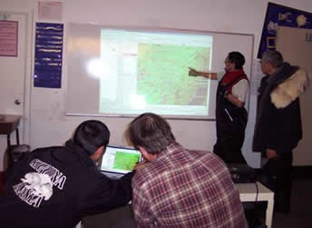
Dr. Yuri Gorokhovich and local hunters from Kivalina village use GIS to map subsistence resources.
.jpg)
Dr Gorokhovich during the polar night in January in village of Selawik.
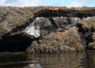
Mapping coastal erosion stimulated by the permafrost thawing near village of Selawik
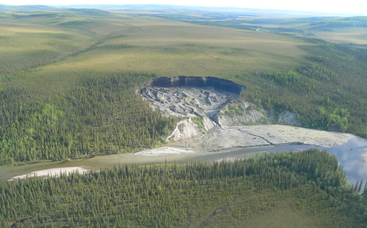
Subsidence and landslide in the upper reaches of Selawik river
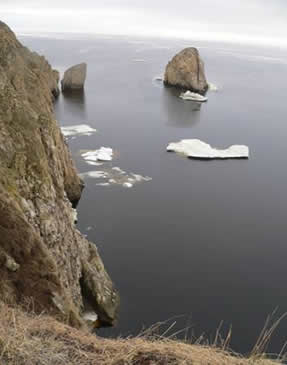
Coastal landforms in Kotzebue Sound near Deering village.
2005 – 2008. Deglaciation of the western Greenland coast. This project was conducted together with Dr. Vincent Rinterknecht from University of St. Andrews. Original funding was obtained from the Climate Center of Columbia University and later from PSC-CUNY Award, City University of New York. The field work included mapping, measuring weathering rates with Schmidt hammer and cosmogenic sampling for Be10 isotope analysis. Our research suggested much faster deglaciation of the western Greenland coast due to the lower ice thickness during the Last Glacial Maximum (i.e. 20K years ago) than predicted by glacial and climatic models.
Publications:
- Gorokhovich Y., V. Rinterknecht, J. Rogers. 2009. Post-Younger Dryas deglaciation of the Greenland western margin as revealed by spatial analysis of lakes. Journal of Earth Surface Processes and Landforms, 34, pp. 801- 809.
- Rinterknecht V.R., Y. Gorokhovich, J. Schaefer, M. Caffee. 2009. Preliminary 10Be Chronology for the Last Deglaciation of the Western Margin of the Greenland Ice Sheet. Journal of Quaternary Science, 24 (3) pp. 270-278
Photos:
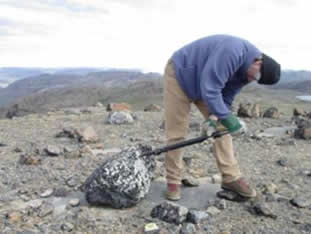
Dr. Gorokhovich samples moraine boulders with jack hammer.
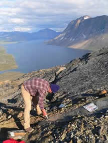
Dr. Gorokhovich measures vertical angles of horizon with compass. This is necessary to account for variation in isotope concentration at the sampling site.
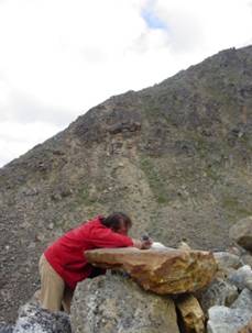
Dr. Gorokhovich measure weathering rate of the exposed glaciated surface with Schmidt hammer.
Our transportation in Greenland
2007. Assessment of the earthquake damage in five Peruvian cities. This project was conducted as a part of the NSF grant “Social and Environmental Vulnerability in Disasters: Spatial Analysis and Information Management for Humanitarian Decision Making”. Field work was done by the joint team from John Hopkins University (School of Public Health) and Lehman College. Lehman College team included Dr. Yuri Gorokhovich and two undergraduate students, Ms. Shiloh Herbert (geology major) and Ms. Andrea Diaz (journalism major). We provided mapping and modeling support to John Hopkins team and used Schmidt hammer to define strength of mortar and bricks in intact and collapsed buildings. Results of this investigation showed that the quality of mortar in public structures was lower than in private structures. This means that the government should provide better control over the quality of public buildings.
Publications:
Gorokhovich Y., S. Doocy, A. Voustianiouk, C. Small. 2010. Assessment of mortar and brick strength in earthquake-affected structures in Peru using a Schmidt Hammer. Journal of Performance of Constructed Facilities. American Society of Civil Engineering. Posted ahead of print 16 January 2010. Permalink: http://dx.doi.org/10.1061/(ASCE)CF.1943-5509.0000120
Milch K, Y. Gorokhovich, S. Doocy.2010.The Inppares-JHSPH-CUNY Study Team, and S. Doocy. Effects of Seismic Intensity and Socioeconomic Status on Displacement after the 2007 Peru Earthquake. Disasters. no. doi: 10.1111/j.1467-7717.2010.01188.x
Photos:
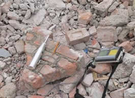
Schmidt hammer was used to measure quality of mortar and bricks in collapsed and intact buildings
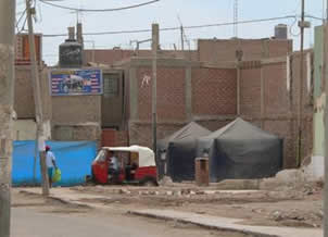
Temporary tents for earthquake victims in Icha.
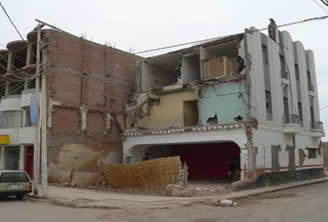
Collapsed building in Chincha.
2007 – 2009. Ancient civilizations and water supply. This project stemmed from my interest in Minoan Bronze Age civilization on Crete. First, like many other people I thought that the demise of Minoan culture was caused by the Late Bronze Age eruption of the Santorini volcano located within 100 km from Crete. However, the more I read about Santorini and its impact on Crete, the more I was convinced that it was not a main cause of the demise. My research led me to the idea of diminishing water supply due to the earthquake activity.
Publications:
- Mays L., Y. Gorokhovich. 2010. Water technology in the ancient American societies. In: Ed. L. Mays, “Ancient Water Technologies”, Springer Verlag, pp. 171 – 200.
- Gorokhovich Y., L. Ullman. 2010. Ground water resources and earthquake hazards: ancient and modern perspectives. In: Ed. L. Mays, “Ancient Water Technologies”, Springer Verlag, pp. 201 – 216.
- Gorokhovich Y., G. Fleeger. 2007. Pymatuning Earthquake in Pennsylvania and Late Minoan Crisis on Crete. Water Science & Technology: Water Supply, Vol 7, No 1, pp 245–251
- Gorokhovich Y. 2005. Abandonment of Minoan Palaces on Crete in Relation to the Earthquake Induced Changes in Ground Water Supply. Journal of Archeological Sciences, 32 (2), pp. 217-222
Photos:
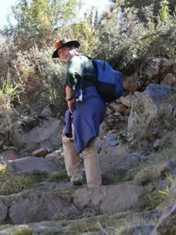
Dr. Gorokhovich walks along ancient aqueduct system in Tipon, Peru.
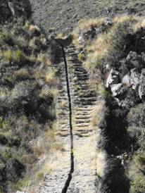
Inca build aqueduct near Tipon, Peru
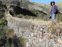
Lower part of the Inca aqueduct near Tipon, Peru
Minoan “lustral basin” in Kommos, Crete
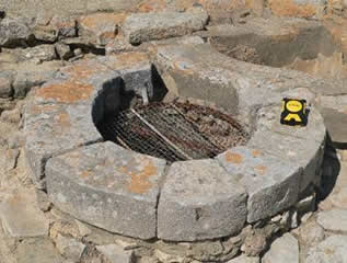
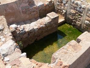
Minoan well at Phaestos, Crete
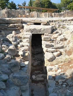
Minoan drainage system (aqueduct?) at Agiya Triada, Crete
- GEO101. Physical Geology. This course is a great tribute to geological sciences. One of the largest misconceptions about geological sciences that it is about rocks only. However, origins of geological science are in philosophical appreciation of natural systems including its traditional components such as lithosphere, hydrosphere, atmosphere and biosphere. Physical geology introduces students to these components and demonstrates applied nature of geological science.
- GEO245. Earth Materials. Chemical elements, minerals, rocks, soils and water are unique components of the earth that provide resources for all types of human activities. This course provides in-depth study of these components and introduces students to basic analysis of minerals, rocks and sediments. Few field trips introduce students to mining in Pennsylvania, New Jersey and sedimentary structures in Long Island.
- GEO236. Environmental Geology. Human activities disturb and change our environment, including its geologic components. The course demonstrates connection between earth resources and human activities.
- GEO 340. Natural Hazards and Disasters: A Multidisciplinary Approach. This course covers natural hazards and disasters, their origins, physical and social implications. It demonstrates how elements of geographic, geological, social and political analysis are applied to risk estimation, mitigation and management. I use in this course Geographic Information Systems (GIS) analysis to teach students how to use spatial data and make maps for decision making.
- GEP635. Natural Hazards and Risk Analysis with GIS. Presentation of fundamentals of the natural hazards and disasters origin, physical and social implications, methods of quantitative and qualitative analysis. Course includes elements of geographic, geological, social and political analysis applied to risk estimation and mitigation and management measures. Geographic Information Systems (GIS) tools and analytical techniques are included in lab exercises and assignments.
- GEP 375. Data and Acquisition Methods for GIS Analysis. This course covers the techniques of data acquisition and their creation for spatial analysis in geographic information systems (GIS). Students will learn various techniques for data capture, processing and analysis. Labs focus on data integration and use of GIS. Few field trips for data collection are conducted on weekends.
- GEP 675.Data Acquisition and Integration Methods for GIS Analysis. The techniques and science of data acquisition and creation for spatial analysis in geographic information systems (GIS). Each student is expected to conduct a term project or participate as part of the group. The project will include field data component and analytical part using GPS and GIS.
- GEO350. Topics in regional geology and mapping techniques: Cretan Geological and Historical Landscape. This course is a part of the study abroad that was proposed in 2010 together with the Department of History. The course will teach students interdisciplinary approach to field work and data interpretation using geology of Crete. Bronze Age (Minoan) settlements on Crete will be used to demonstrate interaction between humans and geological landscape. The course will teach students principles of geology and geologic methods of field investigation and data analysis using Geographic Information Systems (GIS) and Global Positioning System (GPS).The course will teach students how to see geologic features in the field and interpret them, how to find and incorporate spatial data into analytical framework for geological and archaeological analysis. Use of GIS for mapping and data entry will provide students with necessary skills for practical work with collected terrain data and satellite imagery. Labs will use data collected in the field and downloaded from NASA, USGS, NOAA and other sites. Collected data from the field will be a basis for the final field report and its presentation to class.
Yuri Gorokhovich, Associate Professor
Department of Earth, Environmental, and Geospatial Sciences (EEGS)
Lehman College, The City University of New York
301A Gillet Hall, 250 Bedford Park Blvd.
West, Bronx, NY 10468
Phone: 718-960-1981
Fax: 718 960 8584
E-mail: Yuri.Gorokhovich@lehman.cuny.edu